Workers started filling the new Don River valley with water earlier this year. Although it’s now filled, it’s not yet connected with Lake Ontario as one free flowing body of water.
The billion-dollar flood protection project in the Port Lands, which includes the naturalization of the Don River’s mouth, has been nearly a decade in the making.
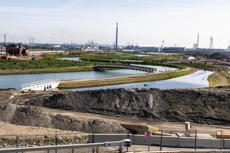
The river valley, although flooded, is currently separated from the Polson Slip by a 10-metre tall concrete wall to the west, which runs 50 metres in length. To cut three metres off the top took about a month.
Workers started filling the new Don River valley with water earlier this year. Although it’s now filled, it’s not yet connected with Lake Ontario as one free flowing body of water.
Everything was going according to plan with filling the new Don River valley with water — until workers noticed a leak.
Water was pouring into the valley from one of three massive concrete walls that temporarily separate the new river valley from surrounding bodies of water.
“Imagine you had a full two-litre bottle of pop,” said Don Forbes, Waterfront Toronto’s project director overseeing remediation and earthworks. “You take a knife and you put a half-inch vertical slice in it.”
ARTICLE CONTINUES BELOW
While the walls will eventually come down and connect the river valley with the lake as part of the $1.35-billion flood protection project in the Port Lands, the riverbed needed to be filled through pumps and stabilized first — slowly.
Engineers had to keep the flow rate from water coming through the pumps equal to the rate produced by groundwater welling up from below, balancing the pressure, so things would settle at the same rate along the new riverbed.
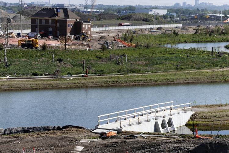
Pumps were turned on Jan. 31 to fill the new Don River valley from water through the Polson Slip. (Mahdis Habibinia / Toronto Star)
“I was concerned about filling the valley too quickly,” said Forbes of the added water the leak was contributing. “If things settle at different rates, then you could end up with river bank slopes collapsing and sloughing off into the river valley.”
The Port Lands’ massive reclamation project, which includes the re-naturalization of the Don River’s mouth, has been nearly a decade in the making and dreamt about for far longer. Earlier this year, pumps roared to life and started filling the new river valley with water through the Polson Slip, marking a critical milestone.
The water gushing out of the leak in the wall that held back Lake Ontario threatened to upset the finely calibrated project that was relying on the nearby pumps to add water at a carefully controlled rate.
A project to celebrate
It’s a significant initiative in the era of climate change, turning an area that long sat derelict because of its polluted history into green space with functional wetlands that absorb excess floodwater as well as carbon, said Jennifer Bonnell, a historian and York University professor who authored “Reclaiming the Don: An Environmental History of Toronto’s Don River Valley.”
“We’re not a city that is historically known for great design initiatives,” she said. “So this is really one to celebrate.”
The Don River used to flow into one of the largest marshes on Lake Ontario at Ashbridges Bay. In the late 1800s, the Don was straightened and separated from the marshlands, which were filled in the 1910s to create a port industrial district. That put the Don into “this straitjacket of a right-angle turn” into Keating Channel, Bonnell said, partly as a pollution abatement strategy.
“About 150 hectares of wetlands were lost,” said Rick Portiss, senior manager of aquatic monitoring and management at the Toronto and Region Conservation Authority. “Toronto used to be teeming with wildlife … we lost that too.”
Return of wildlife
Now, more than a century later, with the river only weeks away from being reconnected to its historic course into Toronto Harbour, both land and aquatic wildlife have returned.
ARTICLE CONTINUES BELOW
ARTICLE CONTINUES BELOW
Once the river valley was filled, the locally endangered American eel returned, along with fish such as walleye and northern pike, which have been limited in number in Toronto because of the lack of habitat, according to Portiss.
“When this river is fully online, it will be a game changer,” he said.
Tearing down the walls
While the river valley is now filled, it’s not yet a free flowing body of water and won’t be until September, with plans to open it to paddlers in summer 2025. The next step is to connect the various bodies of water to the new valley, which would finally make the Don River whole, all the way into Lake Ontario.
That step requires a lot of complicated work around the three walls, called plugs. Because some of that work is being done underwater, it’s not immediately noticeable.
The current stage calls for the removal of the three submerged concrete plugs: the north one separates the current Don River from the new river valley; the west plug is where the new river will flow into the harbour and the re-naturalized river mouth; and the south plug is where the Don Greenway meets the Shipping Channel, which connects to Lake Ontario.
The river valley, although flooded, is currently separated from the Polson Slip by a 10-metre tall concrete wall to the west, which runs 50 metres in length. To cut three metres off the top took about a month.
Ryan Walker/Vid Ingelevics/Waterfront Toronto
The 10-metre tall west plug, which is 50-metres long, will be the first one removed this summer, marking the project’s next critical milestone.
ARTICLE CONTINUES BELOW
ARTICLE CONTINUES BELOW
A massive move
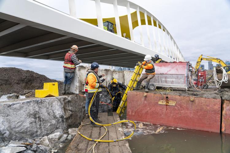
Right now, workers and machines are slicing the wall into 10 pieces. Divers drill holes in the wall underwater and feed a diamond wire saw through it. The wire is attached to a machine on shore that turns, slicing through the concrete, cutting 10 to 15 feet per day.
Workers have to slice the plugs into pieces, underwater, before removing them.
Ryan Walker/Vid Ingelevics/Waterfront Toronto
Each piece will weigh about 45 to 55 metric tonnes, Forbes said — about 99,000 to 121,000 pounds.
Cutting such a massive piece takes time. To slice three metres off the top of the west plug (to allow room for a barge to hold the excavator that will remove some pieces) took about a month, Forbes said.
A solution for the leak
With stakes being so high for what’s billed as one of the biggest infrastructure projects in North America, the surprise leak in such a tightly controlled and engineered environment caused a couple of extremely tense days this spring.
But workers were quick to respond: after crunching the numbers, they came up with a solution.
“We left it,” said Forbes. “We basically just turned down the flow rate on the pumps we were using to inundate the river and ... used the leak to flood the river valley, too.”


To join the conversation set a first and last name in your user profile.
Sign in or register for free to join the Conversation