Death toll rises as Beryl pummels Texas with tornadoes, 90 mph gusts, leaving over 2.7 million without power
Beryl was downgraded to a tropical storm late Monday morning and then a tropical depression Monday evening, but it was still wreaking havoc along its journey further into Texas. The storm center passed just outside the Houston metro area, pummeling the nation's fourth-largest metro area with hours of wind gusts over 70-80 mph and dumping over 10 inches of rain, leading to flash flooding.

Tropical Storm Beryl bringing tornado threat into Monday night
Tornado Warnings are popping up across the Texas, Arkansas and Louisiana state lines as Tropical Storm Beryl moves across Texas. The storms is a low-end tropical storm with 45 mph winds and expected to move northeast into the Lower Mississippi Valley tonight.
MATAGORDA, Texas – Hurricane Beryl crashed ashore along the central Texas coast early Monday morning, pummeling the area with 90 mph wind gusts that brought life-threatening storm surge, widespread damage, and knocking out power to well over 2.7 million people while leaving at least three dead. As it moved inland, the cyclone spawned tornadoes across Texas, Louisiana and Arkansas.
Beryl was downgraded to a tropical storm late Monday morning and then a tropical depression Monday evening, but it was still wreaking havoc along its journey further into Texas. The storm center passed just outside the Houston metro area, pummeling the nation's fourth-largest metro area with hours of wind gusts over 70-80 mph and dumping over 10 inches of rain, leading to flash flooding.
A Tornado Watch was posted for parts of Texas, Louisiana, Arkansas and Oklahoma as the threat of tornadoes increased as Beryl moved inland. Multiple tornadoes were reported in East Texas and Louisiana, ripping roofs from homes and uprooting trees.

(FOX Weather)
On Monday evening, Lieutenant Governor of Texas Dan Patrick confirmed three deaths from Beryl in the state.
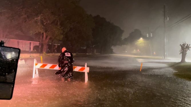
Harris County Sheriff Ed Gonzalez said in a post on X, formerly Twitter, that a tree fell onto a home in the Kings River Village area, trapping a man under the debris. Gonzalez said the man was reportedly sitting inside the home with his family riding out Beryl when a large tree fell onto the house. His wife and children were unharmed.
A few hours later, Gonzalez said a second death was reported after a tree fell onto another home, killing the woman inside.
A Houston Police Department civilian employee was killed as he was on his way to work during the hurricane. Officials said 54-year-old Information Security Officer Russell Richardson was caught in rising floodwaters.

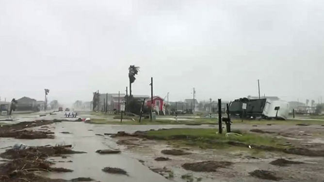
Hurricane Beryl causes significant damage in Clute, Texas
Hurricane Beryl caused significant damage in Clute, Texas, including downed power lines, overturned 18-wheelers, damaged homes and businesses, flooded roads and extensive tree damage when it made landfall near Matagorda.
HOUSTON BERYL TRACKER: LIVE FORECAST MAPS, TROPICAL WEATHER ALERTS, RAIN, WIND, PROJECTIONS AND MORE
The cyclone’s powerful hurricane-force winds have been leading to skyrocketing power outages. Over 2.7 million electrical customers in Texas have lost power, according to PowerOutage.us, and the numbers continue to rise.
Gusts hit 94 mph in Freeport, 89 mph in Matagorda Bay, 84 mph at Houston Hobby Airport and 82 mph at Houston Intercontinental Airport.

Hurricane Beryl Top Wind Reports
(FOX Weather)
And while Galveston hit 86 mph for a top gust, the city recorded three straight hours of 70 mph wind gusts early Monday morning.
 Image 1 of 21
A vehicle is left abandoned in floodwater on a highway after Hurricane Beryl swept through the area on July 08, 2024 in Houston, Texas. Tropical Storm Beryl developed into a Category 1 hurricane as it hit the Texas coast late last night. (Photo by Brandon Bell/Getty Images) ( )
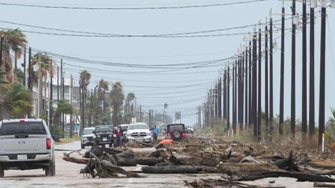
 Image 2 of 21
Debris blocks FM2031, the main access road, after Hurricane Beryl came ashore nearby Monday, July 8, 2024, in Matagorda. (Jon Shapley/Houston Chronicle via Getty Images) ( )
 Image 3 of 21
Vehicles are left abandoned in floodwater on a highway after Hurricane Beryl swept through the area on July 08, 2024 in Houston, Texas. Tropical Storm Beryl developed into a Category 1 hurricane as it hit the Texas coast late last night. (Photo by Brandon Bell/Getty Images) ( )
 Image 4 of 21
Hurricane Beryl strikes Roseneurg, Texas. (Roseburg (Texas) Police)
 Image 5 of 21
Hurricane Beryl strikes Roseburg, Texas (Roseburg (Texas) Police)
 Image 6 of 21
This image shows an RV on its side and debris in the road in Surfside City, Texas, after Hurricane Meryl made landfall on Monday, July 8, 2024. ( )
 Image 7 of 21
Hurricane Beryl comes ashore along Galveston on July 8, 2024. ( )
 Image 8 of 21
Hurricane Beryl comes ashore along Galveston on July 8, 2024. ( )
 Image 9 of 21
This image shows a traffic light that was brought down from Hurricane Beryl’s powerful winds in Surfside City, Texas, on Monday, July 8, 2024. ( )
 Image 10 of 21
Buffalo Bayou floods near Downtown Houston just after Hurricane Beryl made landfall on Monday, July 8, 2024 in Houston. (Raquel Natalicchio/Houston Chronicle via Getty Images) ( )
 Image 11 of 21
Residents assess a fallen tree in their in their neighborhood after Hurricane Beryl swept through the area on July 08, 2024 in Houston, Texas. Tropical Storm Beryl developed into a Category 1 hurricane as it hit the Texas coast late last night. (Photo by Brandon Bell/Getty Images) ( )
 Image 12 of 21
Firefighters check on a house in Rosenberg, Texas, on July 8, 2024. Hurricane Beryl made landfall Monday in the southern US state of Texas, where some residents were evacuated over warnings of flooding and power outages. (Photo by Mark Felix / AFP) (Photo by MARK FELIX/AFP /AFP via Getty Images) ( )
 Image 13 of 21
A destroyed trailer sits near beach homes after Hurricane Beryl came ashore nearby Monday, July 8, 2024, in Matagorda. (Jon Shapley/Houston Chronicle via Getty Images) ( )
 Image 14 of 21
Damage to a home in Spring, Texas on July 8, 2024 from Hurricane Beryl. (Spring Fire Department)
 Image 15 of 21
Brent Meads films himself as he stands in the heavy wind and rain from Hurricane Beryl on Monday, July 8, 2024, in Bay City. Meads said he came from Las Vegas to experience a hurricane for the first time. (Jon Shapley/Houston Chronicle via Getty Images) ( )
 Image 16 of 21
A group of people hide behind a car to shield themselves from wind and rain from Hurricane Beryl as they film videos for social media Monday, July 8, 2024, in Bay City. (Jon Shapley/Houston Chronicle via Getty Images) ( )
 Image 17 of 21
Debris blocks FM2031, the main access road, after Hurricane Beryl came ashore nearby Monday, July 8, 2024, in Matagorda. (Jon Shapley/Houston Chronicle via Getty Images) ( )
 Image 18 of 21
( )
 Image 19 of 21
Damage to a home in Spring, Texas on July 8, 2024 from Hurricane Beryl. (Spring Fire Department)
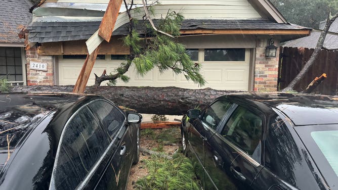
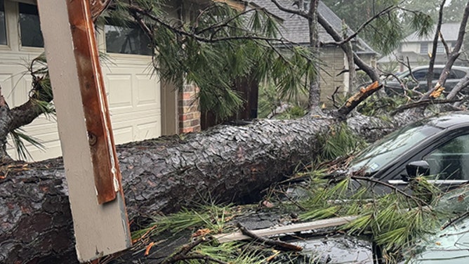
 Image 20 of 21
A large tree fell across a home and cars in Spring, Texas during Hurricane Beryl on July 8, 2024. (Spring (Texas) Fire Department)
 Image 21 of 21
A vehicle drives through heavy rain on a highway during Hurricane Beryl on July 08, 2024 in Houston, Texas. Tropical Storm Beryl developed into a Category 1 hurricane as it hit the Texas coast late last night. (Photo by Brandon Bell/Getty Images) ( )


WATCH: BERYL'S HURRICANE-FORCE WINDS CAUSE WIDESPREAD POWER OUTAGES, FLASH FLOODING IN TEXAS
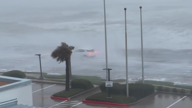
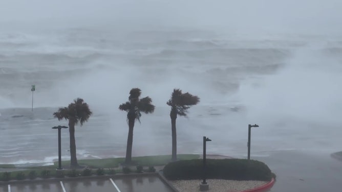
Storm surge was forecast to reach 3-7 feet in some spots near Beryl, and water pushed into the Texas coast and bays along Beryl's approach. Measurements at Morgan's Point along the shores of Upper Galveston Bay reached 5.4 feet above the mean high water level, now the third-highest surge on record. It also had the highest storm surge since it reached 7.78 feet during Hurricane Ike in 2008.
Readings earlier in the morning reached 3.2 feet in Sargent and 2.6 feet in Matagorda Bay, but those gauges have since ceased reporting, possibly due to power outages.

Watch: Storm surge flooding forces FOX Weather crew to seek higher ground
The Surfside Beach Fire Department escorts FOX Weather to safety after storm surge flooding from Hurricane Beryl begins to rush inland on Monday, July 8, 2024.
"That (storm) surge is just pouring into Treasure Island," said FOX Weather Storm Tracker Mark Sudduth. "You could literally see it pouring in like a raging river right now."
The ferocious gusts blasted torrential rainfall, falling at rates of 2–4 inches an hour.
"It feels like the entire backs of my legs are on fire because it stings," Merwin said as she reported live from Surfside Beach, Texas early Monday morning. "The raindrops almost turn into a needle head. Almost like, as if you were getting a tattoo. Like, it's that kind of feel of that persistent needle pressure against your skin."

Traffic light falls during Hurricane Beryl winds in Surfside Beach, Texas
The force of Hurricane Beryl was seen in Surfside Beach, Texas, early Monday morning as the storm unleashed powerful winds and torrents of heavy rain in the area.
The National Weather Service in Houston reports flash flooding is ongoing in parts of the Houston Metro area. As much as 10 inches of rain have fallen across the Huston metro, and rainbands from Beryl persist across the metro.
As Beryl continues northward, it’ll bring rain and strong winds as far north as Michigan by the end of the workweek.
Beryl’s current forecast cone shows the storm will weaken as it moves north but maintains tropical depression strength from Arkansas through Michigan throughout the week. A tropical depression is a cyclone with maximum sustained winds of 38 mph or less. Unlike tropical storms and hurricanes, tropical depressions are identified by numbers rather than names.

Tropical Storm Beryl forecast cone.
(FOX Weather)
The Weather Prediction Center outlined an area from Arkansas through central Illinois that could see flash flooding Tuesday into Wednesday.
Beryl’s destructive past
Beryl's third landfall in Texas culminates a 10-day trek that began on June 29 in the Atlantic and spanned much of the Caribbean Sea, first smashing into the Windward Islands as a Category 4 hurricane.
It then swiped at Jamaica and the Cayman Islands as it crossed the Caribbean Sea and made a second landfall on Mexico’s Yucatán Peninsula as a strong Category 2 hurricane.

Jamaica left reeling after Hurricane Beryl swipes the southern end of the island with damaging winds, storm surge
FOX Weather Correspondent Robert Ray shows us the destruction left behind along the southern shores of Jamaica after Hurricane Beryl swept by just offshore as a Category 3 storm.
The storm left at least 10 people dead as it made its journey across the Caribbean.
Texas was Beryl’s third and final landfall before the storm is forecast to deteriorate as it moves northward through the U.S.