

On Monday, February 19, trucks full of sand began to arrive on what was left of the beach at Fire Island Pines as part of the effort to reinforce the dunes that had been washed away. Earlier this month, teams contracted by the Army Corps of Engineers had pumped 20,000 cubic yards of sand from about a mile out onto the shores of another Fire Island community, Ocean Beach. Suffolk County then worked toward distributing the sand by truck to a string of imperiled beach towns heading east along the barrier island, including the one I have spent two decades going to, the Pines. The sand dump, which took some political wrangling to make happen so quickly — unsurprisingly, the Army Corps is a bureaucratic organization and hard to budge — was an emergency effort necessitated by a series of vicious and, in their frequency, unprecedented storms over the past two winters that had essentially erased stretches of a $207 million beach-fortification effort that had been completed in 2019. The project had been designed to withstand a 44-year storm event but got Swiffered away in four.
We all know, in the back of our minds, that Fire Island as we know it is not going to last forever. It’s a series of seasonal resort towns built on a 31-mile-long sandbar that is ephemeral by its very nature, meant to continually give and take with the tides and wind. Something not so easily done with multimillion-dollar homes planted along its edge.
My husband, who has been going to the Pines for 49 years, and I own a house on the side of Fire Island that looks across the Great South Bay to Long Island. The sunsets are spectacular, and we’ve often been a bit more protected from the storms that pummel the oceanside homes more directly. Although this year, nobody has felt protected.
The price you pay for the idyllic beauty of the place is how vulnerable it is to the forces of nature. Hurricanes and nor’easters strike periodically, dragging decks, pools, entire houses out to sea. Fire Island is a mere four miles off the coast of densely developed suburban Long Island with its highways and shopping malls and subdivisions, but it’s car free and stretches of it are sandy parkland. The rest is low-slung, weather-beaten, and mostly unpopulated offseason. It’s the beauty of the place, and gives it an almost seafarer culture where storm calamity has long been the stuff of legend. And most of the carnage happens in the winter. By the time visitors arrive around Memorial Day, the damage has been repaired.
But lately, the bad weather just hasn’t let up. The “unnamed storm event” out of the Gulf on December 18 hammered the island with what was described as “the destructive power of a Category 1 hurricane.” Buoys 50 miles out measured wave heights of 27 feet before breaking (not the waves but the buoys). Swells of 14-to-16 feet thundered onto shore, reducing what remained of the dune system by half, if not more, particularly on the western end of the Pines. The ocean severed one of two vital roads the town uses for emergency vehicles, while on the bayside, wash-overs and erosion 20 feet deep perilously flirted with dunking an electrical substation.
Suffolk County by then estimated that Fire Island had lost double the amount of sand in 2023 as it did in 2022.
As 2024 dawned, my husband lamented, “Storms we used to get once a year now happen every week.” And then, like clockwork, the monster of January 9-10 arrived, vicissitudes of tidal force fueled by unfortunate planetary alignment. “I’ve never seen this much flooding off the bay,” our property manager reported in a rather distressed and disorienting FaceTime from our deck while our lot was submerged in whitecaps.
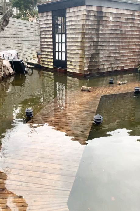
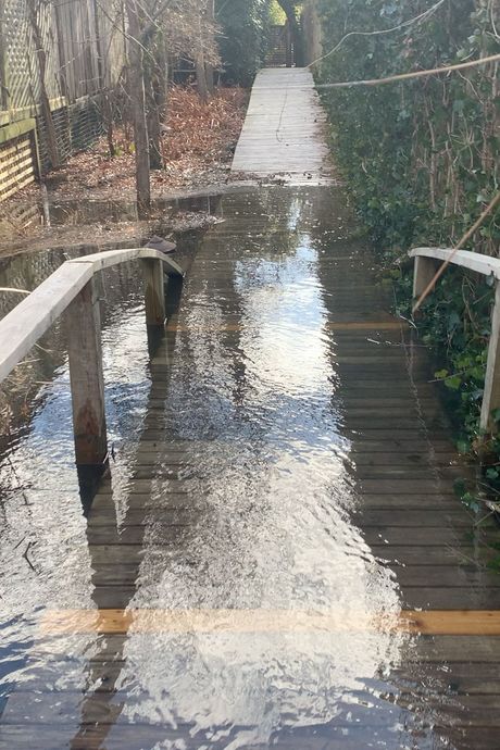
Two days later, the severe flooding along the South Shore of Long Island subsided, ferry service resumed, and we were able to see the aftermath firsthand: the harbor dock and plaza covered in sea debris, repeatedly inundated by the elevated bay. Fire Island Boulevard, an unpaved sandy strip that runs the length of the Pines and divides it and is the closest thing we have to a proper road, since everything else is boardwalks, was flooded because of groundwater overflow tied to sea-level rise. A quaint turtle pond at the western edge of the Pines doubled in size, cutting off access to a couple of houses.
Tuna Walk, the boardwalk that passes by our house and leads from the boulevard to the bay, has been lifted several inches by bay and groundwater surge, planks blown out, flotsam everywhere. It’s weird to see what sloshes about in times like this: solar pool covers still on their spools askew in shrubs; hefty concrete planters splayed like bowling pins.
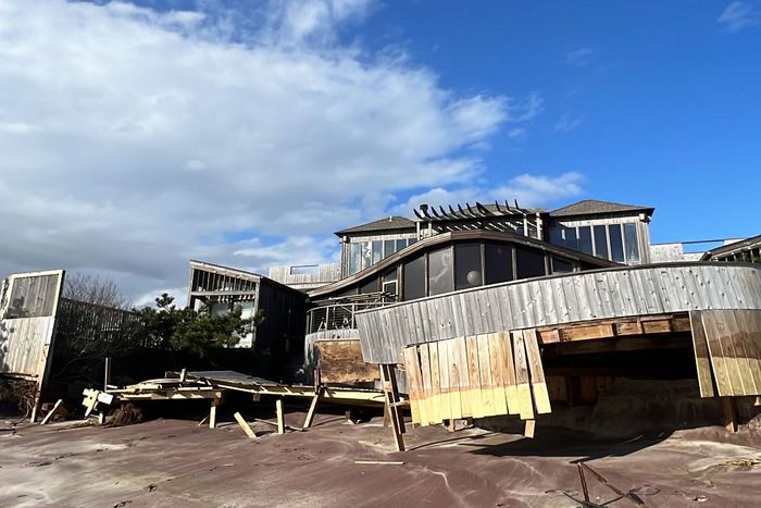
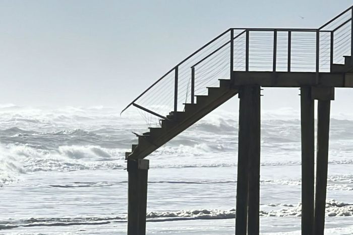
Across the boulevard, on the oceanside of the island, the main beach-access point for emergency vehicles now drops at an abrupt 75-degree angle for at least a dozen feet, the beach ADA ramp destroyed. Access walks that skimmed the dune now resemble piers hovering menacingly at vertigo-inducing heights as far as the eye can see.
Which is why we were so glad to see the trucks of sand arrive to save the day — and the summer.
The history of getting the Army Corps to step in — it wasn’t easy to get its attention — this winter goes back a few years.
Hurricane Sandy hit the island hard in 2012, shoving the dune line inward toward the Great South Bay. The mostly seasonal resort communities built on the sandbar had to do something.
In my community, the Fire Island Pines Property Owners’ Association, which for many years had paid to replenish the beach roughly every five or six years, decided to take advantage of the federal Fire Island to Moriches Inlet Stabilization Project—$207 million in funding to rebuild 19 miles of shoreline taking seven years to implement. This created a dune line 15 feet high and over 75 feet wide, along with beaches seemingly as wide as a football field. It required moving and raising multiple oceanfront homes but, in the process, allowed the town to shrug off the wet blanket that had stifled property values, as beach advocates believed the stabilization would last generations. The only catch — a point that now stirs recrimination and resentment — was that in accepting the federally financed and engineered project, the Army Corps would have say over future sand replenishment.
The Pines is arguably the most famous of the Fire Island communities. For many people, its fabulousness has been synonymous with Fire Island itself. (For a recent example, see Joel Kim Booster’s gay burlesque Fire Island.) Never mind that, neighboring Cherry Grove aside, the rest of the island hamlets — some family friendly, some fratty, some preppy, some middle class, some more upmarket — are not historically queer Xanadus.
But what that means for the Pines is that the residents will fight fiercely to preserve this place. Many residents are survivors of the AIDS crisis, which hit the Pines hard. Veterans recall the mid-’80s nadir of the epidemic when two-thirds of the houses on their walk sat empty. The plague depressed real-estate values, but it made the place politically organized (GMHC was co-founded by Pines residents). Empathetic, nature-loving folk who have been through some real shit and know how to fight (or party) for a purpose. Some credit the island — its glorious beach, crystalline light, trench-warfare camaraderie — with having saved them during the worst of that crisis.
More recently, younger queer people who know little of the plague years beyond what they see on a Ryan Murphy production have increasingly taken it for their own and the island has become more diverse. It’s still a place apart from day-to-day heteronormativity.
Then COVID, coupled with the arrival of high-speed broadband enabling remote work (before that, the spotty Wi-Fi and cell reception made that annoying to impossible), brought in a new generation of young, prosperous owners. Between 2020 and 2023, roughly 30 percent of the housing stock changed hands, according to Henry Robin, president of FIPPOA, the town’s property-owners association. Many of the long-term residents cashed out as a prosperous new generation was willing to pay more than houses had ever gone for before with plans to justify their investment through higher rental prices. Houses selling for under $1 million became a rarity, $2 million now stretches to $4 million, quaint cottages morphed into showy five-bedroom houses designed to be easily monetized. At this point, there are few good deals.
All this gentrification wasn’t paying much mind to climate-change-induced sea-level rise, which is now around double what it was in the 1990s. As outlined in a sobering 2023 assessment from Newsday, citing NOAA reports, seas off Suffolk County have increased six inches since 2000 and are expected to rise another three inches by 2030, swelling almost another foot by 2050. From there, it projects oceans could go into overdrive — expanding an additional three-to-five feet by 2100. The bayfront will bear the brunt of that: With a one-foot rise, NOAA’s Sea Level Rise Viewer shows the wilderness area between the Pines and Cherry Grove, known as the Meat Rack, as a vast inlet, something it resembled with dead-on accuracy this January; at two feet, that inlet expands to where the edges of both communities start to resemble Venice, while the boulevard largely disappears. Gulp.
Pines owners, old and new, realized last year that the post-Sandy beach replenishments already needed shoring up.
First came the devastation of the December 2022 and January 2023 storms that decimated the dunes on the western end of the Pines to the point where FIPPOA petitioned through Suffolk County for rehabilitation assistance from the Army Corps. But it was turned down.
Then came the staggering one-two punch of Hurricane Lee and Tropical Storm Ophelia over ten full days in September 2023 with “erosion of a magnitude that corresponds to a 500-year storm,” according to the State Department of Environmental Conservation. Despite the now-drastic reduction in beach and dune, the Army Corps denied another appeal, claiming the severity — based on its meteorological assessment — failed to meet the legislated criteria to qualify as an extraordinary storm event. It also noted that, even if renourishment were deemed necessary, federal funding would need to be secured before any construction contracts could be awarded.
That left the few remaining eternal beach optimists to hold out hope that the natural annual process of southerly breezes or storms, as opposed to the detrimental east-northeasterly ones, might still drive some of the offshore sand back to land.
No such luck.
As the season ended last year, Pines residents began to feel anxious. The Army Corps was, I was told, “like a black box.” Residents sensed that the community’s incremental, localized, “Let’s not ruffle feathers” approach simply wasn’t making headway fast enough, particularly on the heels of the September wipeout. Activist backgrounds and survival instincts kicked in. Alongside a PR and political campaign from Actum, a firm hired by FIPPOA and the Seaview Association (Seaview is another beach hamlet on Fire Island), it was time to go rogue. “We knew we had to start shaming them,” one ACT UP veteran recalls. “The only reason we’re alive is because we demanded the NIH and FDA give us the drugs now. And we need sand on the beach now.”
The ask was that the Army Corps, which had a sand-dredging operation finishing up work on the western end of the island (responding to storm damage from 2019), would stick around longer pumping up sand to replace what had washed away in other communities at the eastern end of the Island, including the Pines. (The Army Corps had been planning on moving the dredging equipment further east to shore up Montauk next to address emergency repairs initiated in 2015 as part of a separate project.)
A faction of political operatives with media know-how (a description that could apply to half the town) orchestrated a public-facing pressure campaign to parallel the critical work being done through Town of Brookhaven and Suffolk County officials. Their goal was to raise and maintain public awareness with a call to action: The Army Corps needed to step up. IG handles such as @beachplease_fi methodically highlighted carnage, while a camera feed covered the deteriorating oceanfront IRT. Those with media connections worked to get the word out. It was a sexy story (in a Schadenfreude way) that was made for local news.
In late September, FIPPOA organized a meeting-of-the-minds Zoom with a Who’s Who of politically connected residents in the Pines (“Powerful people you’d never know were here,” as one person told me), some with direct lines of communication to Senators Schumer and Gillibrand and Governor Hochul’s office. The meeting ignited earlier outreach, and letters started to fly: The first from Senator Schumer, in calling for emergency repair, was portrayed as blasting Army Corps inaction. Senator Gillibrand firmly followed suit, coupled with a call to Army Corps top brass.
But still the Army Corps was unconvinced, claiming its hands were tied by the letter of the law: The situation did not meet technical thresholds as legislated in order to release the funding needed to stop along the way to Montauk.
Then the policy wonks in the offices of both U.S. senators got to work, doing a tandem deep dive into the original FIMI legislation, written a decade ago post-Sandy, seeking a work-around aligned to today’s accelerating climate. They realized that if they aggregated the severity across back-to-back storms, as opposed to weighing each event separately, that would meet thresholds and unlock federal funds.
From there, everything started to click. On January 14, Senator Schumer announced that the Army Corps had agreed to conduct an expedited review based on cumulative storm severity. One week later, Governor Hochul announced $3 million from New York State to help pay for emergency repairs. On January 26, the Army Corps finally said “yes,” declaring a state of emergency that allows the eastern communities of Fire Island to qualify for an emergency repair.
The rub is getting the Army Corps to spring into action quickly enough: It took the USACE four years to execute repairs in the western communities of Fire Island tied to 2019 storms, which is why the dredging equipment was already nearby. Funding needs to be available before the dredging itself — a huge logistical operation these days with equipment in constant demand from Florida to Maine thanks to the same forces that are affecting Fire Island — can be scheduled.
On the first weekend of February, the dredging company agreed to pump stopgap sand at Ocean Beach that will be distributed by Suffolk County in large trap bags to eastern communities. By mid-month, trap bags began working their way along the island, hamlet to hamlet, from Seaview to Davis Park. Proportional shares were TBD, and given the collective beachfront desperation, “it’s like The Hunger Games,” noted one Pines owner who followed the process closely. As for the major repair, there remains the long-shot hope that the Army Corps, now described as “committed and actively at the table,” might schedule work later this spring, after completing its work in Montauk (it’s also considering other dredging outfits).
Looking ahead, this is mostly a Band-Aid. FIPPOA has environmental task forces formulating action plans for bayfront-seawall remediation (early prognosis: It will need to be uniformly and markedly raised to meet 2050 projections) as well a long-term solution for the swamped town roadbed. Robin himself is spearheading a solution for the town’s septic systems, which already fail in flood-prone areas during peak season (ew), possibly necessitating a sewer line. Who foots the bill for all this is TBD. Meanwhile, get a whiff of JIF: One Bayfront couple’s homeowner-insurance premium just leaped from $7,800 to $15,629.
Was it wrong to call in chits from elected officials who then fundraise on Fire Island? There are plenty of ethical and environmental arguments still swirling, as there should be, surrounding a pricey, publicly funded project that might seem to be there to protect a playground of the relatively privileged.
While “Fire Island as an entity has a long time to go,” as Henry Bokuniewicz, a professor at Stony Brook University’s School of Marine and Atmospheric Sciences, reassured the readers of Newsday last year as part of a deep dive the paper did on climate change’s effects, it’s clear that Fire Island as we know it will change whether we like it or not. The pumping and dumping of the sand has just staved off that, for now. The question is how we’ll adapt and how much longer Fire Island will be able to be preserved and enjoyed — and at what cost.


