
OMAHA (DTN) — The governors of Iowa, Minnesota and South Dakota over the weekend each issued emergency declarations as heavy rains that began late last week flooded rivers throughout the region.
Flood warnings remain in place Monday and areas south of those already hit are expected to see major rivers cresting through at least July 1.
A swath of counties in northwest Iowa, southwestern Minnesota and southeastern South Dakota saw rainfall Thursday to Saturday that ranged anywhere from 5 to 8 inches in most areas and as much as 15 inches in some spots, according to the National Weather Service.
“An area from about Mitchell, South Dakota to Albert Lea, Minnesota may have got the worst of the flooding, but it is more extensive than that,” said DTN Ag Meteorologist John Baranick. “Heavy rain fell in that general area but also east through southern Wisconsin, northern Illinois, and into parts of Michigan. These areas may have been able to handle the heavier rain better, as they had not seen the extensive rainfall that those western areas experienced prior to the deluges last week, but heavy rain has been a large nuisance and damaging factor for the northwestern Corn Belt for much of the last couple of months,” Baranick said.
He added more rain is coming. “The forecast is not dry, either. A frontal boundary will move through these flooded areas Monday and Tuesday with scattered showers with another coming through Thursday and Friday with more. Showers and thunderstorms may be hit-or-miss, but any hits would only prolong the damage.”

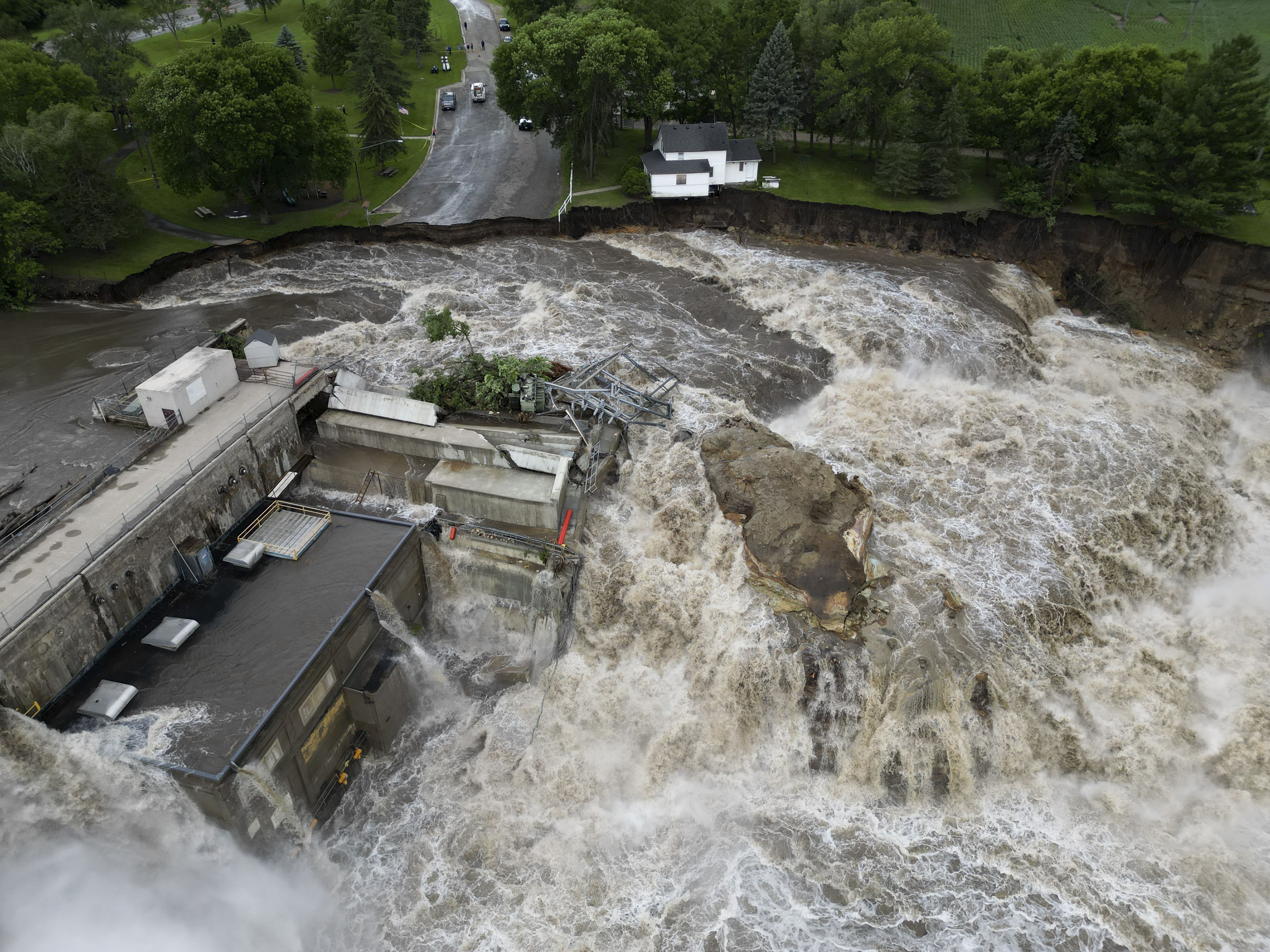
State disasters declared
Iowa Gov. Kim Reynolds declared a state disaster for 22 counties after touring the flooded areas on Saturday. On Sunday, Reynolds requested an expedited presidential disaster declaration that would access programs from the Federal Emergency Management Agency, Small Business Administration and USDA.

“While we’re still very early in the response, the projected damage is staggering,” Reynolds said. “It is estimated that at least 1,900 properties are impacted and hundreds have been destroyed.”
Interstate 29 was closed in South Dakota and in Iowa on Monday morning due to the flooding.
About 100 miles farther northwest, the town of Spencer, Iowa, with more than 11,400 people, faced catastrophic flooding over the weekend and was largely cutoff with its roads and highways closed.
In Rock Valley, Iowa, a town of 4,000 residents, emergency sirens at 2 a.m. Saturday morning alerted residents that the Rock River was flooding and people should evacuate.
Iowa officials noted the floodwater from rivers such as the Big and Little Sioux rivers is flowing into the Missouri River and will cause downstream flooding.
Minnesota Gov. Tim Walz had a request much like Reynolds’, calling in the Minnesota National Guard to deploy to Waterville, Minnesota, on Sunday morning to cope with flooding on the Cannon River.
“Flooding has left entire communities under feet of water, causing severe damage to property and numerous road closures,” Walz said in a news release.
Areas such as Mankato, Minnesota, saw as much as 8 inches of rainfall Thursday and Friday. The Minneapolis Star-Tribune reported Windom, Minnesota, would see a record flood level for the Des Moines River.
Governor Kristi Noem in South Dakota also reported at least one person had died in her state from severe weather. “All I’m going to say is that I want to remind everybody to remember the power of water and the flow of water, and to stay away from flooded areas,” Noem said Sunday in a news conference.
Nebraska Gov. Jim Pillen ordered National Guard helicopters to help Iowa with rescues.
In Iowa, most state highways in northwest Iowa had some form of road closure.
Railroad impacts
Two major railroads in the region were seeing bridge closures and track damage in the Iowa-Minnesota-South Dakota region. BNSF lost a bridge over the Big Sioux River between Iowa and South Dakota.
“That is the main bridge going into Iowa that a lot of commodities and different materials move on throughout the state,” said Noem said in a news conference Monday. “That’ll impact us for many, many months to come.”
While grain elevators in flooded regions are likely coping with several other immediate challenges, they likely aren’t moving grain anytime soon.
Kendall Sloan, a spokesman for BNSF, said the railroad had been monitoring the Big Sioux River before the bridge was destroyed. “All trains are being rerouted via Creston, Iowa. We will continue to monitor and inspect conditions in the area and across our network and execute recovery operations as needed.”
Robynn Tysver, a spokeswoman for Union Pacific, said rail crews are repairing tracks damaged by heavy rains and flooding this past weekend in northwest Iowa and southwest Minnesota. Two different routes into St. Paul, Minnesota, have been closed to traffic due to the floodwaters, and traffic has been rerouted to avoid the impacted lines, she stated.
The Union Pacific line between Mason City, Iowa, and St. Paul, Minnesota, closed Saturday. It is expected to reopen late Monday or early Tuesday morning. The line between Sioux City, Iowa, and St. Paul, Minnesota, also closed Saturday. We do not have an estimate on when it will reopen at this time.
Crops in standing water
It may be too early to determine crop damage, but most of the Missouri River bottom fields were already in standing water before this past deluge.
Kelly Nieuwenhuis, who farms near Primghar, Iowa, posted videos and photos on social platform X reporting 3 inches of rain that had flooded his fields. “I think we’re at a new all-time rainfall amounts for a single spring in NW Iowa!!! It’s a mess.”

Nieuwenhuis said 2024 was the most rain his farm had seen, though there was flooding in 2018 and 2019. He said he expects tiling he had installed would help, but added, “We won’t have a large number of acres affected, but many aren’t as fortunate. I’ve got water sitting in areas and if it doesn’t go away soon those crops will die from lack of oxygen in the soil, I’ve seen 3ft corn with 2 inches of water on the ground die from this in the past!!,” he added. “Unbelievable how much water went over roads Friday night.”
In Omaha, the National Weather Service predicts the Missouri River will rise 12 feet over the next week to a forecast of a 34.5-foot crest, which would compare to flood levels in 2019.
Chris Clayton can be reached at Chris.Clayton@dtn.com. Follow him on social platform X @ChrisClaytonDTN
![]()


