
Aspen Skiing Co. has closed the operating boundary around the skier’s right and bottom portion of the new Hero’s terrain on Aspen Mountain, in a departure from its preexisting open-boundary policy in place with few exceptions across its four local ski areas.
The move to close the boundary, unveiled when the company released this winter’s trail map in August, came in part at the request of landowners of two adjacent parcels, one of which is being marketed as a multimillion dollar real estate investment. The closure also speaks to the risk — associated with the ski-area expansion into the area historically known as Pandora’s — that developing the terrain could result in more unwitting skiers making a dangerous descent toward the North Star Nature Preserve.
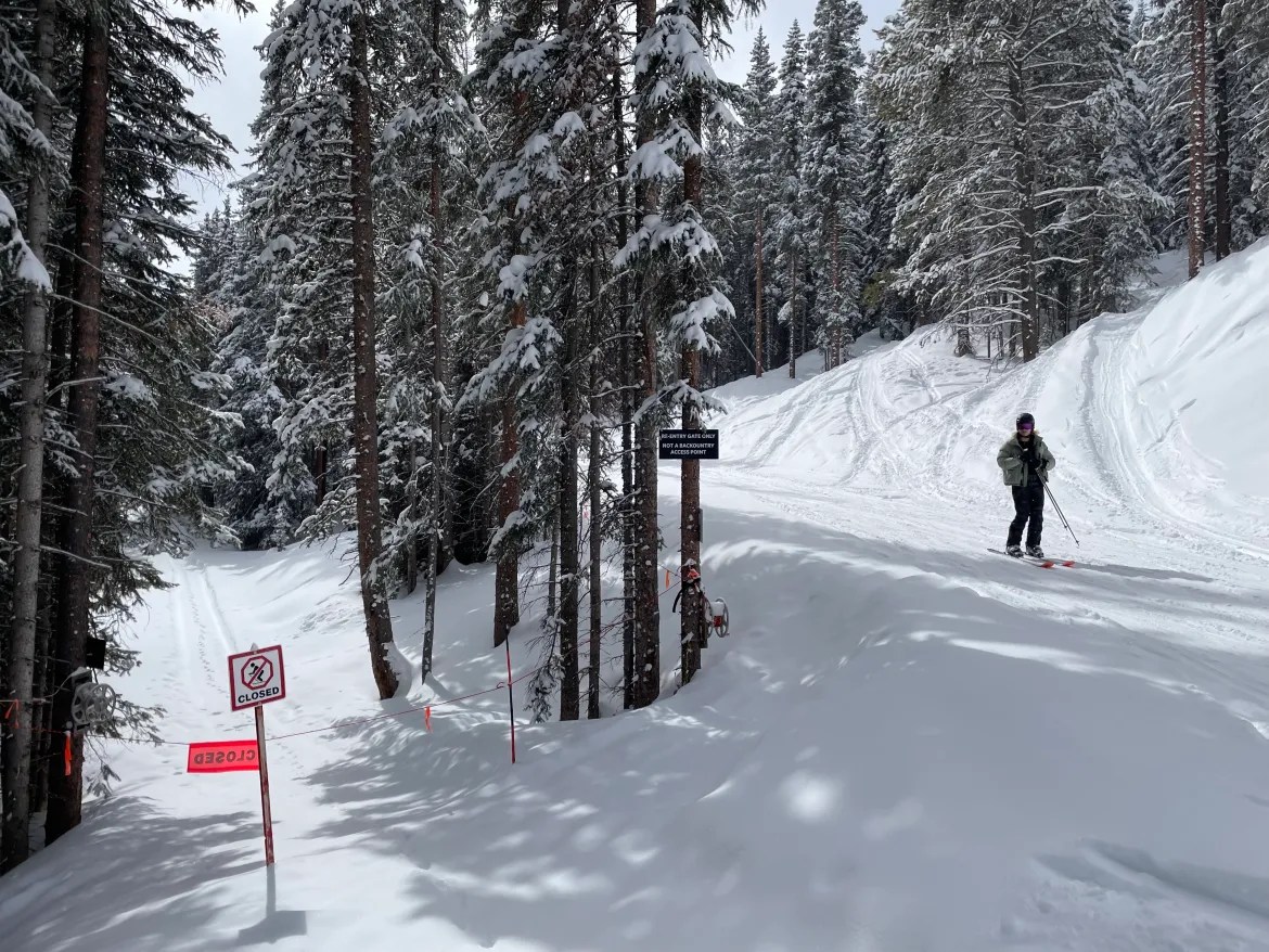
Although the closure and the trail map may create the impression that backcountry access is complicated without a return to the ski area, there is, in fact, a gate that allows for reentry to the ski area beneath runs marked as part of Hero’s Chutes #1. That means that skiers who use existing legal public access at the top of the new lift to ski public lands outside the boundary can return to the ski area along a traditional backcountry route when the Hero’s terrain is open.
The mechanics and implications of the closure are reflective of the complicated land-use picture on the backside of Aspen Mountain, with its mixture of rural and remote public and private lands, and its cherished recreational and community-character values.
The open-boundary policy in place across the rest of Aspen Mountain and, with few exceptions, the other SkiCo ski areas — Aspen Highlands, Buttermilk and Snowmass — dates to the late 1970s and says guests are permitted to leave the ski area and return to it at any point, so long as the points of departure and return are in open terrain. That access comes with the disclaimer that backcountry travelers assume all inherent risks and are responsible for their own safety.
The open-boundary policy helped to popularize the Pandora’s terrain — previously easily accessible from the top of the Silver Queen Gondola — with a return traverse to the ski area near the bottom of the Walsh’s run. The Pandora’s terrain now encompassed by Hero’s was used by between 646 and 980 skiers per month, according to a game-camera count from December 2019 through early March 2020 furnished by SkiCo as part of the county approval process for the expansion. Further recreational activities accessed via the backside of Aspen Mountain and Richmond Ridge include SkiCo’s Powder Tours’ snowcat skiing operation; touring beyond the ski area for backcountry skiing and to reach overnight huts; and avalanche-safety education courses put on for decades by Aspen Expeditions and other outfitters.

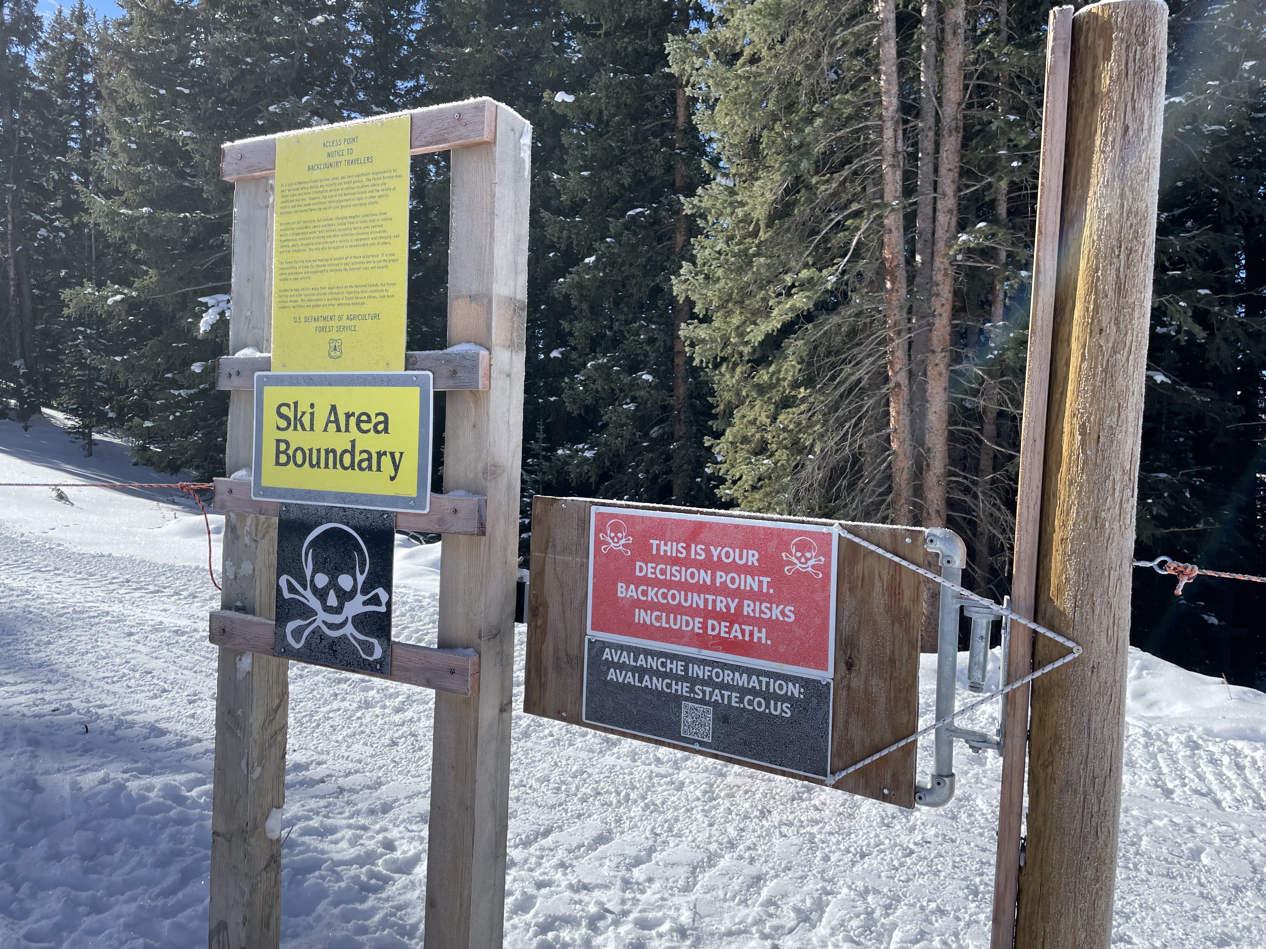
The ski-area boundary above the new Hero’s high-speed quad, which tops out on the ridge at an elevation of 11,262 feet, remains open with a standard backcountry access gate leading to Richmond Ridge Road.
But the boundary goes from open to closed along the ski area’s southeastern edge, where it descends from the ridge to the skier’s right of the Harris’s Wall run. The closure remains in place across the bottom of the entirety of the 158-acre terrain expansion, where the boundary also abuts public land. Signs along that portion of the boundary warn that terrain below is dangerous and leads to a “closed wildlife habitat area” where entering results in a $1,000 fine.
Jeff Hanle, SkiCo’s vice president of communications, who declined to make any other company representatives available for this story, noted the unique nature of the Hero’s boundary and surrounding terrain. He said via email that mountain managers decided to close the boundary after receiving input from property owners both adjacent to the expansion and on the valley floor below.
In 2019, lawyers representing the owners of properties adjacent to the Hero’s boundary, which carry development rights to build two 1,000-square-foot cabins, requested that SkiCo provide signage along the boundary following their property line showing that the land beyond is private and there is no access.
However, there is legal public access through that private property along a recreational easement that Pitkin County secured in 2018 as part of a lawsuit settlement with the landowner, Valley View Ajax. The easement is meant to ensure public access to public lands south and east of the ski area, beyond the private land, and to allow backcountry tourers who ski down from Richmond Ridge to cross the private property on their return to the ski area. The easement follows a traditional backcountry route along Loushin’s Road. Also, where the road intersects with the Buddy System trail, there is a gate that skiers can use to reenter the ski area through the otherwise-closed boundary when the terrain is open.
A sign next to the gate states that it is “not a backcountry access point” and is only for reentry to the ski area.
The easement, however, allows for public ski access in both directions across the Valley View Ajax property to and from U.S. Forest Service lands.
Assistant Pitkin County Attorney Ry Neiley said the sign prescribing only one-way use is “probably not representative of the public’s right to use the easement.”
In an email, Hanle said SkiCo “can open and close the gate as we deem necessary for safety reasons. We will continue to allow skiers to reenter at the gate when it is safe to do so.”
He did not address questions about whether the company should be able to prevent the public from exiting the ski area on the recreational easement, as is implied in the current signage. SkiCo is not a party to the easement agreement, which was completed prior to approval of the expansion.
Partition, access and development rights
Valley View Ajax— whose ownership group includes developer Jeffrey Shoaf and Bridger Smith, who along with brother Colter Smith is involved in the local real estate and development industry — agreed to grant the recreational easement in 2018 in exchange for an easement along a lower portion of Loushin’s Road that permits their private vehicular access in the summer months across three properties owned by Pitkin County. That easement trade allows the Valley View Ajax owners to drive to their properties from the Aspen downtown core via the Aspen Mountain Summer Road, as well as helped to settle a lawsuit brought in 2017 by a predecessor in interest to Valley View Ajax against Pitkin County and the U.S. Forest Service.
Aspen Mountain and the terrain to the south and east of its operating boundary consists of a web of private and public land, resulting from historical mining claims both on the face of the mountain and along Richmond Ridge. Thanks to this legacy of private holdings mixed with public lands, dozens of cabins — some rustic, some luxurious — dot the landscape from the backside of Ajax past Little Annie Basin.
The new Hero’s terrain and the Valley View Ajax property are part of the Iron Silver Placer mining claim. Until 2014, SkiCo and Shoaf were owners, as tenants-in-common, of property consisting of this and four other mining claims near the top of Aspen Mountain. A settlement that year partitioned the property along what is now the ski area boundary in Hero’s. SkiCo retained land in the settlement that now makes up some of the gladed, expert terrain in the expansion, while what became Valley View Ajax gained control of the land south and east of the partition line.
Valley View Ajax then divided its land into the two parcels that are adjacent to the expansion terrain. Both have multimillion-dollar development potential.
The Smith brothers are in the process of developing a 1,000-square-foot cabin, the maximum size allowed in Pitkin County’s rural-and-remote zone district, on the northern parcel, which shares the longer border with the ski area boundary. In September, Bridger Smith, president of Valley View Ajax, secured the necessary land-use approvals needed to apply for a building permit.
The other Valley View Ajax parcel, which sits just to the south of the Smith parcel, is advertised for sale online by Shoaf, with a list price of $8 million or a buy-in option at $2 million. That parcel carries a development right with an approved activity envelope for a new 1,000-square-foot cabin and contains a historic 500-square-foot cabin that could be redeveloped. The existing cabin and potential new cabins have access to potable water and electricity, as the Valley View Ajax land contains a pond and infrastructure including a powerline and pumping system that serves the Sundeck on Aspen Mountain. The Valley View Ajax cabins are able to hook into these utilities based on an agreement with SkiCo.
Advertising material online for the property being sold by Shoaf boasts that a new owner could “take the skier’s right off of Hero’s high speed lift and ski right to your cabin through the Hero’s Chutes #1.”
Doing so, however, would not be permissible due to the boundary closure, according to SkiCo.
“Private landowners adjacent to Hero’s have been asked to use the Richmond Ridge gate and travel down to their properties,” Hanle wrote in an email.
Valley View Ajax representatives did not respond to requests for comment.
A private agreement with SkiCo
When the expansion project then known as Pandora’s first appeared in front of the Pitkin County Board of County Commissioners on April 10, 2019, local attorney Chris Bryan spoke during public comment on behalf of Valley View Ajax.
“We want to make sure that SkiCo provides roping and signage that the land behind the ropes and signs there is private and there’s no access,” Bryan said. “We have some assurances from SkiCo that’s going to happen. We would like to see that be a condition of approval.”
David McConaughy, Bryan’s colleague at Garfield & Hecht law firm, had sent a letter dated April 5, 2019, to the county’s community development department expressing general support for the Pandora’s expansion but requesting a closed boundary between the expanded ski area and the land owned by Valley View Ajax.
“VVA requests that a condition of approval is a commitment by SkiCo that there will not be any open boundary gates between the Aspen Mountain ski-area boundary and VVA’s property and that SkiCo will specifically provide roping and signage that the land behind the ropes/signs is private and there is no access,” McConaughy wrote.
The letter and statements made during public hearings did not reference the 2018 recreational easement that allows for public access across the Valley View Ajax properties.
In late April 2019, Bryan reported to the BOCC that his clients were “close to reaching a private agreement with SkiCo.”
According to Colorado’s Ski Safety Act of 1979, owners of land that adjoins ski area boundaries may close all or part of their land, and the ski area is then required to put up signs that reflect the closure.
SkiCo’s open-boundary policy does not sanction trespassing on private land. The policy states, “If you choose to leave our boundary, you are responsible for knowing where you are and where you are going. You may not trespass after leaving the boundary.”
The final county approvals for the expansion project, which included a rezoning of 130 acres of land from the restrictive “rural-and-remote” category to “ski-recreation,” were granted in November 2021, more than two years after the initial public hearings. They did not mention anything about a closed boundary.
“The county staff and the [commissioners] had no real position on closing the boundary,” Neiley wrote in an email.
In September, the U.S. Forest Service approved SkiCo’s updated operating plan, which includes the boundary policy, for the new terrain.
“We generally defer the specifics of operating the ski area to the operator, in this case Aspen Skiing Co.,” White River National Forest public information officer David Boyd wrote in an email.

Safety, wildlife concerns drive closure along bottom boundary
Beyond the boundary and the adjacent private property, there is some challenging, complex terrain. The expansion brings that terrain in closer proximity to the ski area.
Additionally, backcountry runs that continue beyond the ski area to the valley floor push skiers to cross either private property or the closed North Star Nature Preserve on their way to Highway 82.
The preserve includes a protected open space closed to public access that lies at the foot of Aspen Mountain, downhill from the end of the Walsh’s and Kristi runs. Skiers and riders who end up in North Star Nature Preserve violate that closure, which is meant to protect wildlife habitat, and face fines from Pitkin County Open Space and Trails.
In January 2019, Pitkin County open space staff offered comments on the proposed Aspen Mountain Master Plan, which laid the groundwork for the ski area expansion.
“OST has issued tickets and fines for trespassing into this closed zone in the past, but would like to work with the Aspen Skiing Co. to prevent this issue in the future as it has the potential to be exacerbated with the Pandora’s expansion,” the staff wrote. “Additional signage at the ski area boundary may help to educate and alert skiers that exiting the eastern boundary will funnel skiers onto protected lands and/or private property where they will be subject to fines.”
The Pitkin County Sheriff’s Office printed signs last ski season that warn of dangerous terrain and fines for entering the closed wildlife habitat area. Those signs now dot the downhill boundary line of the Hero’s terrain.
Hanle and Parker Lathrop, who is with the Pitkin County Sheriff’s Office, express concern about inexperienced or lost skiers ending up in dangerous terrain below the Hero’s chairlift.

Lathrop said the sheriff’s office receives calls each season from skiers who end up stuck on cliffs below Walsh’s run. Aspen Mountain Ski Patrol is often called upon to help when Mountain Rescue Aspen and the Pitkin County Sheriff’s Office receive rescue requests from stranded skiers in that area.
“It can and has put our patrol, Mountain Rescue and the sheriff’s office [personnel] at risk performing rescues,” Hanle wrote.
Hanle added that SkiCo is concerned about the safety of employees and guests within the Hero’s terrain as well. Avalanche danger is a particular concern, especially when ski patrol is actively working in the Hero’s area.
“If people exit the ski area at the top on the access route along Richmond Ridge and ski down, they may not know that Hero’s is not open and they may try to enter the ski area lower down when [avalanche] control work is being performed above them,” Hanle wrote. “Or, if they duck the rope to get back in — [which is] not advised — they may come in above patrol that is working below them.”
That could put ski patrol members in danger of slides from above. Hero’s is not the only terrain where this danger exists; elsewhere, according to SkiCo’s open boundary policy, skiers and riders are expected to know about and heed closures and could face fines of up to $1,150 and loss of skiing privileges for entering and/or skiing closed, in-bounds terrain.
With the closed boundary, skiers and riders who duck out of the ski area under boundary ropes could be subject to fines up to $1,000 under Colorado’s Ski Safety Act. If someone violates the boundary closure and is reported to the Pitkin County Sheriff’s Office, a deputy could issue a court summons for violation of the Ski Safety Act, Lathrop said. Property owners could also prosecute for trespassing.
The other areas where a closure adjoins the ski area are Loge Bowl on Aspen Highlands and a lynx mitigation area near Burnt Mountain Glades on Snowmass.

Closure cuts off Difficult run
Before the expansion and the boundary closure, skiers such as Mikey Wechsler had been making use of SkiCo’s open boundary policy and skiing runs in the Pandora’s area for decades.
The closed boundary cuts off the fall line in an area below the Harris’s Wall run that Wechsler and his old ski gang, the Dogs, would pass through on their way to ski a run called Difficult, which ends on the valley floor near Difficult Campground along Highway 82. The backcountry run involves several traverses, a hike and a game trail.
“It’s basically, well, I guess that’s over. We had a lot of good years back there,” Wechsler said. “I guess I skied Difficult for my last time. I’m not going to risk whatever, lose my pass, just to ski something, [even if] it’s probably going to be great.”
But Dan Harris, a ski buddy of Wechsler’s and the namesake of the Harris’s Wall run, said even with frequent signage and risk of fines, he anticipates skiers will continue to venture out of bounds, toward the valley floor.
“I’m sure people will keep skiing it,” Harris said. “After Harris’s gets skied out, they’ll just go drop down the way we always have.”
Wechsler, too, expects that people will duck the rope, especially if there are tracks leading beyond the boundary.
“There are so many clueless people out there, and that area is pretty ripe for that because it doesn’t look that hard,” Wechsler said.
But Wechsler and other members of the Dogs ski gang say they won’t be skiing it.
“It’s kind of the end of an era,” Wechsler said. “Change is going to come in everything, and you either roll with it or you’re bitter. And life’s too short to be bitter.”