

The “unique nature” of the border between resort and adjacent land around the skier’s right and lower portion of the new Hero’s terrain on Aspen Mountain is among the justifications offered by Aspen Skiing Co. as to why a decades-old open boundary policy does not apply there, as reported by Elizabeth Stewart-Severy in a detailed piece for our Connie Harvey Environment Desk.
Certainly there are not many land-use contexts like the backside of Aspen Mountain, where public and private land straddle the horizon at the intersection of a pristine high-country ridge and the top of one of the world’s premier ski resorts.
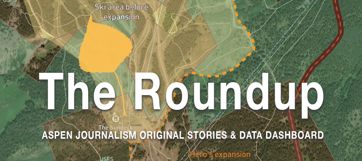
Before the new terrain on Aspen Mountain in the area long known as Pandora’s opened in December, you could duck the boundary rope anywhere to the right of Walsh’s and come back at a point of your choosing as long as the in-bounds terrain was open, as laid out in the open boundary policy in effect with few exceptions across all four local resorts. Touted by the local ski company as a progressive policy supporting backcountry exploration, it helps underpin values that are central to community identity.
But now that the Pandora’s terrain is in bounds, with a speedy new quad chairlift expanding commercial skiing into terrain that used to be a locals secret, the private land next door is worth a lot more. Lawyers representing the Valley View Ajax ownership group of local real-estate-industry folks worked on “a private agreement with SkiCo,” back when the ski-area expansion first came before Pitkin County commissioners in 2019, following pleadings for signage telling the public to keep out of the private enclave once the new terrain came online. Now that it has, the closed boundary is in place and about half of the VVA land plus the right to build a 1,000-square-foot slopeside ski chalet is now for sale for $8 million.
The closed boundary continues along the bottom of Hero’s, as the adjacent land changes from private to public, based on a concern that descending from that portion of the terrain puts skiers onto an exceptionally dangerous slope that ends on the valley floor in a wildlife-closure area in the North Star Nature Preserve.
You can still exit the resort along Richmond Ridge Road at the top of the new lift. And thanks to an easement secured by Pitkin County in 2018 that protects recreational access across the VVA property between public lands to the southeast and the ski area, there’s still a legal access to reenter the resort along the Buddy System trail.
While these arrangements throw a lifeline to the area’s historic backcountry-use culture, the right to exit the ski area at Loushin’s Road has been withheld, per the SkiCo’s current signage, despite the county easement providing for two-way access. And those who would cut through private land at the bottom of Harris’s Wall to reach an advanced backcountry run to the valley floor must cross the closed boundary line, risking a violation of the Ski Safety Act.
Skiers exploring the terrain in the 1970s named it Pandora’s for a reason. We are in the process of finding out what happens when the box is opened, with impacts that will ripple out for years. This is one part of the story.
Could the Shoshone water-rights deal risk Roaring Fork flows?
By locking up one of the most significant water rights on the Western Slope with the pending Shoshone water-rights deal that would protect Colorado River flows through Glenwood Canyon, a regional water protection alliance risks harming an already imperiled stretch of river along the Roaring Fork upstream of Aspen.
Or at least that is a concern Pitkin County is paying a consultant to explore as the Colorado River Water Conservation District sets about trying to raise $98 million to buy the Shoshone hydropower water right from Xcel Energy, as detailed by Water Desk Editor Heather Sackett in an Aspen Journalism piece published last week.
How that could be is thanks in part to Colorado’s system of water administration where the oldest water rights get first use. In short, the upper Fork benefits when irrigators in the Grand Valley with 1912 water rights need to “call” for their water when flows get low in late summer. This “Cameo call,” as it is known, shuts off the 1930s rights that send Roaring Fork headwaters to Twin Lakes (then Colorado Springs, Pueblo and Aurora) — and that provides a critical boost to streamflows when the upper Roaring Fork needs them most. But the Shoshone rights date to 1902. So, if the River District more aggressively asserts its right for the water than the current owner, it could in theory pull more down the mainstem of the Colorado, reducing the need for the Cameo call and keeping the upper Fork’s diversion flowing to Twin Lakes when it would otherwise have to shut down.
Like most things in water, this will be studied closely, probably for years, and is subject to final negotiations between impacted users. Pitkin County Attorney John Ely told Sackett he is optimistic that a resolution can be reached, at which point the county would be in a position to support the River District’s Shoshone permanency campaign. “We’re not looking to get in the way of Eagle and Garfield and Mesa counties protecting themselves,” he said, “but we don’t want to sacrifice our river for them to be able to do so.”
Water on the auction block
Earlier this month, Sackett traveled to Longmont to witness an auction for shares of water in the Colorado-Big Thompson project that recently became available. It was a sight to see as potential buyers representing agriculture, municipalities and real estate development committed more than $4.7 million in the span of about an hour to buy the rights in perpetuity for a total of about 63 acre-feet of water each year. Read her report on the state of the northern Front Range marketplace for water, much of which is imported from the west side of the Continental Divide.
As always, thank you for reading and supporting Aspen Journalism.
– Curtis Wackerle
Editor and executive director
Aspen Journalism


SkiCo closes Hero’s ski area boundary, impacting backcountry access
Closure aims to keep public out of private property and wildlife area
By Elizabeth Stewart-Severy | February 22, 2024
The move to close the boundary, unveiled when the company released this winter’s trail map in August, came in part at the request of landowners of two adjacent parcels, one of which is being marketed as a multimillion dollar real estate investment. Read more.


Pitkin County exploring concern that Shoshone deal could harm Roaring Fork
Upper Fork ‘lives and dies’ on the Cameo call
By Heather Sackett | February 21, 2024
Pitkin County in November hired Golden-based engineering firm Martin and Wood Water Consultants to do a technical analysis and modeling of the Colorado and Roaring Fork rivers. Read more.

Auction of Colorado River water nets $4.7 million
Bidders paid an average of $74,600 per acre-foot
By Heather Sackett | February 16, 2024
According to Shuman, of the 15 buyers, six were farmers; four were dairies; two were developers; two were municipalities and one was a farm foundation. Read more.


Data dashboard: Swinging air temperatures
Roaring Fork snowpack down to 96% of median
By Laurine Lassalle | February 26, 2024
• Snowpack in the Roaring Fork basin reached an average of 12.2 inches of snow-water equivalent per site on Feb. 25, or 96% of median.
• Lake Powell was 34.2% full on Feb. 25, down from 34.4% last week.
• High air temperatures at the Aspen airport went from 48°F on Feb. 6 to 29°F on Feb. 11 before going up to 47°F on Feb. 19 and dropping to 36°F on Feb. 22.
There are always stories that need a journalist to pursue them. These Aspen Journalism investigative stories are published for you, the community, and our collaborators as a public service, thanks to the generosity of our readers and funders.